
James W. Earl

[In this wonderful photo essay, James Earl brings to light some of the mysteries of those myriad patterns on the ground that many of us see from the air as we fly across the country.]
For a few years I flew back and forth regularly between Indianapolis and Eugene, Oregon, maybe twelve times in all. I always took a window seat, because I like to watch the landscape below. To me it’s the greatest show on earth—after all, it is the earth. I’ve only met a few other serious window-seaters like myself. Most people prefer the extra comfort of the aisle, and most people assigned to window seats pull down the shades. Not me.
One time about four years ago, after taking off from Indianapolis, I found myself absorbed more thoughtfully than usual in the farmland below. I realized I was observing so many things in the landscape for the first time that I would never remember them all. That happens a lot as I get older. The feeling always comes with the thought, “I’d better write this down to remember it.” This time it came with another thought: “I wish I had a camera to help me remember this!”
Afterwards, although I didn’t know what I was going to do about that camera, I told friends I was thinking of writing something called “Window Seat,” for people who didn’t know what to look for from 30,000 feet up. I imagined a little book the airlines could tuck into the seat pocket by each window. I talked about it with geographers at the university. Everyone seemed to think it was a great idea, even though I’m not a geographer. Everything I know about geography I learned in the window seat.
My friend Kenny Helphand, a landscape architect, told me he’d already seen a book called Window Seat: Reading the Landscape from the Air, by Gregory Dicum; my sister knew of another, America from the Air: a Guide to the Landscape Along Your Route, by Matthews and Jackson; and my father passed along an article from a travel magazine, entitled “How to Look Out an Airplane Window: the World at 30,000 Feet.” But these writers weren’t interested in the sorts of things I was seeing over Indiana that day four years ago. Since then, Kenny has given me a lot to read about American landscape. Still, I’m not a geographer, just a serious window-seater.
Here are some examples of what those writers aren’t interested in.
I’d always known in some way about the strict north-south/east-west grid of Indiana’s roads, and of the whole Midwest, and much of the country for that matter. From Indianapolis to Eugene, surveyors have laid out America in neat one-mile squares. It was Thomas Jefferson who invented the grid, in the Land Ordinance of 1785; the Homestead Act of 1862 extended it west of the Mississippi. Technically it’s called the PLSS, the Public Land Survey System. I always took it for granted until I went to Europe, where property lines are a lot less orderly.
I remember the very day I became aware of the American grid here in my home town of Eugene. For years I walked my dog every day at sunrise. The sun rises at a different spot on the horizon every day, and one day it dawned on me (literally) that on March 21, the equinox, it rises right in the middle of the street, due east. The town is laid out like an astronomical calendar, like Stonehenge. If calendars didn’t exist, dog walkers like me would still know when Spring arrived in Eugene. (In New York, since Manhattan tilts strongly to the right, the same thing doesn’t happen until July 11. There, an eccentric cult is developing: people come out on that day to watch the sun go down right in the middle of the street, between the buildings.)
On that day over Indiana I was noticing how roads followed the grid, one mile apart, running due east-west between fields exactly one mile square. It’s like a compass down there: as you fly over it you can tell exactly what direction you’re flying. Along these roads towns had grown up, spaced pretty evenly apart—maybe forty miles?—and smaller ones had grown up half-way between. Those must have started as way-stations, in the days when forty miles was more than a day’s travel. All this is obvious from the air. There’s a geometrical logic to the way towns settled onto the grid, and the way they grew.
Occasionally roads stray off the grid, but they always make their way back. Ah, I thought: terrain. When I lived in Indiana as a kid, we joked about how flat it was—“flat as a pool table,” my father always said. It’s true there aren’t any hills in Indiana that you can see from 30,000 feet, but early travelers taking the levelest route with their horses and wagons did sometimes choose to go around something rather than over it. Terrain like that means less today than it did in the eighteenth and nineteenth centuries, since cars take an incline more easily than walkers, or horses and carriages, so newer roads tend to be straighter.
That’s one of the many things those writers didn’t mention, that you can often tell newer roads from older ones by how straight they are. I was reading the landscape not only in two dimensions, like a map, like the flat surface it appears to be from the air, but in three, detecting elevation by curves in the grid; and not only three, but four, if you count history as the fourth dimension.
Another irregularity you notice against the regularity of the grid, besides elevation, is water: not only rivers and streams, but the water table itself under the ground. From high above, you can see as clear as day, by changes in the color of the soil, where water flows underground, invisible to the earthlings down below.
One Square Mile
Here’s a one-mile square on Indiana’s grid, home to eight small farms.

Since a square mile is 640 acres, these farms average eighty acres, the standard unit of sale in the 1820’s, before forty acres became the rule. We’re about fifty miles west of Indianapolis, near Lebanon. Here, underground water is clearly visible as a pattern of darker brown soil. At first I mistook the spider-webby pattern for cloud-shadows, but there aren’t any clouds. Better to call them “water-shadows.” Now that we’re seeing right through the ground, as it were, you might say we’re reading the landscape in five dimensions.
And now, if we look at just one of these little farms, it seems to be floating on a long island of green over a deep brown sea. Do you see the same 3-D effect I do?

These are very typical Indiana farms, right below the flight path from Indianapolis to Denver. This area must have been settled by small farmers when the mile-square grid was still new, so roads follow the property lines, one mile apart. This isn’t the Great Plains or the Wild West. Out there farmland takes different forms, more vast and even more beautiful to my eye. We’ll get there.
Even here, though, let me not be shy on the subject of beauty. These photos seem to me quite beautiful. Look even more closely at the effects produced by plow lines, for example, which resemble the brush-strokes of a painter.

These photos are oddly painterly. The colors are all natural earth tones, of course, pleasing in themselves—pleasing, because our sense of beauty is derived from Nature. As Emerson says, “The standard of beauty is the entire circuit of natural forms,—the totality of nature.” Even the painter’s pigments are made from the earth, after all.
So Nature, yes; but in these farmscapes there’s a fascinating interplay between the natural and the man-made. A farm is only a very large garden, after all—so large that one can forget the connection. According to Ann Spirn, in The Language of Landscape, “landscape” connotes “a sense of the purposefully shaped, the sensual and aesthetic, the embeddedness in culture.” Or as Simon Schama says in Landscape and Memory, “Landscapes are culture before they are nature.” In other words, it’s not just the land but man’s imprint on it, his relation to it, that makes a landscape. Emerson might say then that that makes it art, which he defines simply as “Nature passed through the alembic of man.” Could it be that we’re actually looking at art?
These photos do resemble landscape paintings, even if we don’t immediately see them that way. They seem abstract at first, because landscape paintings never have this point of view (a bird’s-eye view–except that birds don’t fly at 30,000 feet; I think of it, rather, as God’s point of view). They also lack a horizon and vanishing point, essential in landscape painting for suggesting three-dimensional space and relative distance; they lack sky, the infinity of which suggests the sublime; and they lack those little details of the natural world on a human scale that reveal the relative size of things and suggest our humble place in the world. But they are landscapes, obviously, and sometimes they do manage to suggest the sublime, or make us feel at home in the world.
Perhaps you’re wondering where I got the pictures. It turns out you don’t need to bring a camera on board anymore, because the whole country—the whole world—has now been photographed from satellite, and it’s all available on the internet at Google Earth. Most people who play with Google Earth zoom right in on their houses, but the beauty of America, if beauty’s what you’re looking for, is in its landscapes, and from God’s point of view some of America’s most beautiful landscapes are its farmlands. With Google Earth I can set my computer screen at 30,000 feet and watch the entire flight path from Indianapolis to Denver drift by below me; and after Denver, on to Eugene, or Portland; and I can zoom in on details that catch my interest. Here at the beginning of the flight we’re especially lucky, because the state of Indiana has had itself photographed in especially high resolution all on bright sunny days. Google Earth photos aren’t always this good, but over Illinois, and then Iowa and Missouri, then Nebraska and Kansas, and then over Colorado, and then over Utah and Idaho and then finally over Washington and Oregon, we do get our share of some really wonderful views, right on the computer.
Circles and Squares
I could spend all day in my window seat and not get bored, but in a short essay I need a focus. So here I’ll be looking at farmland only, not cities, rivers, mountains or wilderness; and none of the farms along the route to Denver are more beautiful to my eye than the great circle-fields of the Great Plains, where the impressive geometry of Jefferson’s grid is clearer than in Indiana, clearer than anywhere.

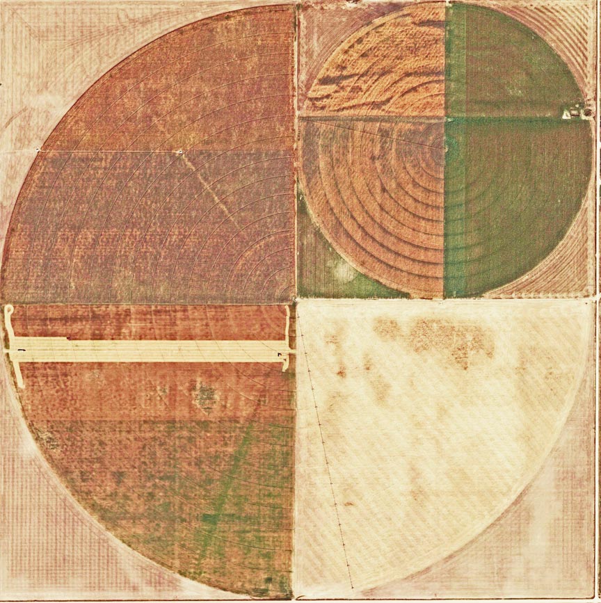
Out here the land is as flat as a pool table, and an agricultural technology has been developed that takes full advantage of that flatness. These circles are produced by the rotating clock-like arms of gigantic robot irrigation machines—“center pivot irrigation,” or just “circle irrigation.” How gigantic? Just as back in Indiana the grid was composed of one-mile squares, it’s the same out here. So here we see twelve square miles of the grid. The large circles on the upper right and lower left are each a mile in diameter—a mile! The smaller ones are a half-mile across.
On the Plains the grid was laid down before the land was bought up and farmed, and of course long before circular irrigation was invented. The wasted space in the corners of each square tells us immediately that the grid is older than the circles. The land’s a palimpsest: modern circles have been neatly fitted into Jefferson’s original one-mile squares. The result is this wonderful geometric effect of circles within squares, which I find beautiful all in itself.
Geographers today are generally critical of Jefferson’s imposition of a purely geometrical grid over the rough topography of the landscape’s natural forms. But Jefferson was an architect, not only of Monticello but of democracy, and the grid is as democratic as it is Palladian in inspiration. As James Corner says in Taking Measures Across the American Landscape(llustrated with wonderful aerial photos by Alex Mclean), “Jefferson was most concerned with making land available efficiently and equitably. The measuring of the American landscape was less about dominion and possession than it was about the democratic and legal sale of land.” The point, he says, was that as many people as possible should have a small piece of land, and “to avoid the wholesale purchasing of large areas by land speculators.”
The grid’s Palladian beauty is especially evident on the Plains, where the addition of circles seems to fulfill an architectural idea as old as the Pantheon and as American as the Capital dome. Circles and squares: Anne Spirn says, “A circle is associated with heaven in many cultures, the annual cycle of seasons, with birth and death, change and becoming. There are more squares than circles in human-built landscapes, and more circles than squares in ‘natural’ landscapes. Is this why squares so often represent reason and order?”
Circles within squares: from above, their symmetry, regularity and endless variations remind me of quilting, or tiling. Here, for example, is a classic American quilt,

and also a tile with a classic Garden of Eden motif
(that’s a fountain in the middle—the earliest circle irrigation).

Because of such homey visual analogues, it’s easy to forget how titanic the scale of circle-fields really is. The entire University of Oregon campus would fit into just one of those large circles.
From here on I will focus just on circle-fields. Perhaps I’m drawn to them because of Emerson’s wonderful essay, “Circles,” which begins, “The eye is the first circle; the horizon which it forms is the second; and throughout nature this primary figure is repeated without end.” Well, it’s certainly repeated without end out here on the Great Plains! As a further focus, I’ll stick with that question which has come to haunt my thinking about these landscapes, the question about beauty, art and sublimity. As you look at these images, try to suspend your interest in farming as much as you can, and think about these circles, if it’s possible, as works of art—a kind of folk art, perhaps? Or, if it’s too great a stretch to consider the farmers as folk artists, could these be, at the very least, examples of art trouvé, “found art” (in this case, found by me on Google Earth)? I’ve spent months at my computer, cruising over tens of thousands of square miles of farmland looking at these giant circle-quilts. Here are six of my favorite spots.
Number One

Here we are in eastern Colorado, about 150 miles east of Denver, near the little town of Burlington. This is my favorite stretch on the long flight home. Here we have six square miles on the grid—five one-mile diameter circles, and, in the upper left, two half-mile ones. For scale, notice the tiny cluster of farm buildings up in that same corner; and what looks like a tiny paper-clip on the right-hand side is really a row of huge grain silos.
Because the circles are only half-harvested, or half-planted, they call to mind some very familiar images: I’m reminded of planetary bodies, or phases of the moon. The two circles on the right especially seem to float over a sky-like background; sunlight reflected off the wet ground there even provides the illusion of clouds. Follow the paths of the tractors, like a painter’s brush-strokes; their patterns create lighter areas which suggest (to my imagination) polar regions on those moons and planets. We may be looking at a farm on the Great Plains, but the imagination, as it always does with abstract patterns, insists on recognizing familiar forms from nature—in this case nature diagramed in a science book, or in the newspaper every morning.
Notice that each of the six squares is different, as were the twelve squares in the previous image—different colors, different crops, different sizes, different tractor patterns. That’s the rule with circle-fields out here on the Plains—not at all what I would have expected. The two smaller circles probably indicate different ownership. Empty spaces outside the circles are filled with traditional fields, mowed in those same patterns of concentric squares and rectangles that I like to create on my lawn with my own little mower. I bet I’m not the only one who takes such care with simple lawn-mowing-patterns, and takes pride in them, even if no one ever notices. I bet farmers feel that way.
The circles-within-squares necessarily leave small (small?) rounded triangles in the corners which require a special mowing pattern, a combination of straight and curved lines that come to resemble braided ropes, or even (here goes my imagination again) Celtic interlace patterns.

Number Two
Moving in a little closer, here we have just four square miles, rather than twelve or six.

My delight in this image has little to do with planets or any other imagined resemblance. It’s more purely abstract, like classical geometry, like abstract art. Why do these fields strike me as so perfectly balanced, so perfectly . . . beautiful? As always, each of the squares is different. I love the two pearl-like small circles above, echoing the larger ones. (Pearls? My imagination won’t quit. I found myself calling this image “Cherry Pie,” before I finally settled on “Farm,” which is what it actually is.) For scale, note the tiny barn in the lower left corner.
I think it’s the surprising patches of red that give this image such life: the pie-slice in the lower right yielding to the vertical slab in that visually shocking square field to its left, rising to the small red circle above, echoed in the background of the upper right. The variety of forms and colors here seems almost . . . calculated. And of course it is calculated, because someone after all did decide to make it like this. Which raises that question again: if these patterns look like art, could it be that they are? Are farmers even aware of what their fields look like from the sky? Could they care? I think they do, even if just in the way I care about patterns when I mow my own lawn.
Number Three
Now we’re down to just one square mile. This image is a circle in a square in a circle in a square, a geometer’s dream. And yet, abstract as it is, it’s vividly realistic too, because if you look very closely at the yellow stripe just south of the “equator,” you’ll see two combines in the process of harvesting, and a truck following behind, picking up the bales.

Naturally I call this image “Harvest.”
When I said we should suspend our interest in farming and consider these images as art, I wasn’t suggesting that we forget that they’re landscapes. They’re never purely abstract. They’re images of something, after all, and that something is very, very large. Scale is important in our aesthetic response. It’s in details like those almost-invisible combines at work that I detect the sublime in these images—as in Chinese landscape painting, where the sublime is suggested not by the horizon or sky, but by a tiny human figure in the distance, which allows us as viewers to experience the vastness of the landscape and also our own smallness in relation to it simultaneously. That paradoxical sensation, exhilarating and humbling at the same time, self-fulfilling and self-negating, is the essence of the sublime.
In each of the corner panels of this one we find slightly different tractor-patterns, as if each worker had his own signature harvesting style. In fact, if we adjust the contrast and look very carefully, we’ll see in the upper left-hand corner, written over an especially nice braided-rope pattern, in huge, scrawly John Deere cursive, one of them has actually left his signature, “John.”

Is this man proud of his work? Is he really signing it, as an artist would? Maybe farmers are aware of what their fields look like from the sky. Maybe they do care. In Ronald Blythe’s Akenfield: Portrait of an English Village, an old farmer talks about plowing with horses back in the 1920’s. “Each man ploughed in his own fashion and with his own mark. A farmer could walk on a field ploughed by ten different teams and tell which bit was ploughed by which. Sometimes he would pay a penny an acre extra for perfect ploughing. The men worked perfectly to get this, but they also worked perfectly because it was their work. It belonged to them. It was theirs.”
Number Four
As harvest-time is bright with autumn colors, plowing-time is dark with bare earth. Here’s another circle-in-a-square-in-a-circle-in-a-square, the smaller circle is just rich brown soil, as yet unplowed, the larger one a complex stair-step pattern of intersecting plow-lines and irrigation rings in black and white.

In the upper right, there’s the shadow of a second small circle, now “painted over,” as it were—so I call this image “Pentimento,” the term used in painting for the still-visible trace of an image a painter has painted over.
Number Five
Oregonians know the pleasure of flying into Portland from the east, coming over Boise and then down the Columbia Gorge past Mount Hood. I like this route, but for my own reason, for here we find some wonderful circles. In Washington and Oregon, however, circles are very different than in Colorado and the rest of the Great Plains. Out here the farmers who brought the new irrigation technology didn’t find a grid of roads already laid out, or square-mile fields established. Now we’re in the Wild West.
Flying west along the Columbia, off to the right side of the plane, just south of Kennewick, Washington, we find a landscape I called “Bubbles” until I learned that it’s really the Hundred Circles Farm, one of the largest circle-farms in America.

This is what it looks like from 34,000 feet—a swath about seven miles long. Here I have to set aside my pleasure in the beautiful quilt-like geometry of the Plains, and enjoy something a little less orderly. Out here farmers waste as little space as possible. Circles are “nested.” Look closely and you can see highways snaking through this vast obstacle course—you need roads, but where there’s so little ground water, better the roads be longer than any land be wasted.
Number Six
My last spot isn’t far from the Hundred Circles, just down the river and off to the left of the plane in Oregon. Almost home.

These circles, each a half-mile across, lie between Boardman and Hermiston. They too are nested, but unlike the Hundred Circles they’re striking for their near-perfect symmetry, more appealing to my classical taste. Oregonians who look at this image inevitably think of logs stacked in a truck. Even the patterns created inside the circles by the rotating arms of the irrigation system remind us of tree-rings—except for the one at the bottom, where someone seems to have gone a little tractor-crazy one day, producing what looks like strands of DNA in a cell.

What happened out there that day? The self-explanatory simplicity of this image (except for that one strange detail) permits us to stop here and reach for some conclusions.
Double-takes
What is it in these simplest of simple forms—squares and circles—imposed on a staggering scale upon the vast landscape of America’s farmlands, that so captivates me? Mostly it’s the double-take produced by beautiful abstract forms, which I have to remind myself repeatedly are actually photos of real landscapes; a kind of rabbit-duck illusion, as my mind swings between seeing them first as representational images, then as abstract art.
I also enjoy a second ambiguity: if these images are art, am I the artist for producing them, or are the farmers the artists, and I’m just discovering their work, like Alan Lomax recording folk songs in the Thirties? It doesn’t really matter, as long as they help us better appreciate the beauty of the landscapes we fly over. One thing we love about art, after all, is that it lets us see in a new way things that we’ve always taken for granted, lets us see them as if for the first time, with new eyes.
I also love the idea of America itself as a work of art. Walt Whitman says, “The United States themselves are essentially the greatest poem. Of all mankind the great poet is the equable man, the equalizer of his age and land. The fruition of beauty is no chance of hit or miss; it is inevitable as life, it is exact and plumb as gravitation, there is not an acre of the earth without it. About the proper expression of beauty there is precision and balance; the art of art is simplicity; the American circles and large harmonies of government gleam with theirs.” That’s from his 1855 Preface to Leaves of Grass. He sounds a lot like Jefferson or Emerson, though on speed. When he says “the American circles,” he doesn’t mean irrigation circles, of course, but I like the coincidence.
In their beautiful simplicity, then, in their precision and balance, in their collectivity, their creation not by individuals but by groups, in their fruitfulness, their huge scale, and the democratic impulse embodied in the grid, the circles of the Great Plains and the Northwest are an example of the American sublime.
And yet Whitman would be appalled by the farms themselves, and for me too they provoke one last surprising double-take. For these are not the eighty-acre family farms of Indiana; no, these huge circles are a sure sign and symbol of modern industrial agribusiness. Whatever happened to Jefferson’s dream of equitable small-scale farming on the grid? Well, the sublime is always threatening, and our response to it is always vexed. If you think green, or organic, or local, it can only seem ironic how beautiful these huge circles are from the air. Then again, everything’s beautiful from the air.
Double-take: look back at the circles and squares, those twelve square miles:
What are those purple pools beside each circle in the lower right?

They’re settling tanks for the waste products from industrial animal barns that have been fitted into the triangular corners outside the circles. We’re looking at chemically treated manure to be sprayed onto the circles as fertilizer. These pictures may be beautiful, but they’re not sentimental. This isn’t the Hudson River School.
However, I’m a lot more sentimental about them than the great aerial-art photographers Alex McLean and Emmet Gowin. The governing theme of McLean’s work is captured in the title of his latest collection, Over: American Landscape at the Tipping Point. Like McLean, Gowin in his book Changing the Earth portrays irrigation circles as just another example of man’s devastation of the planet, like strip mines and bombing ranges, which he also photographs. He shoots his circles in somber sepia, or black and white. This one reminds me of the one I called “crazy tractor day,” above [#6].

In fact this one too is located in Oregon, only a few miles from mine. Gowin is obviously not amused. The environmentalist Terry Tempest Williams says of Gowin’s photos, “What we thought benign becomes malignant.” On their beauty, she quotes Rilke, “Beauty is nothing but the beginning of terror.” To her, Gowin’s circles are “like clocks where time ran out.”
These are ideological as much as aesthetic judgments, harsher than my own. To me, the beauty of our farmlands’ geometries may be ironic, but above all the circle fields are still visually spectacular and intellectually provocative. They don’t make me angry, they make me think. Gowin deserves the last word, though—or at least the last picture—because one of the things I can’t help thinking about now, as I fly over circle fields, is his disturbing response to them.
Norman MacLean says in A River Runs Through It, “All there is to thinking, is seeing something noticeable, which makes you see something you weren’t noticing, which makes you see something that isn’t even visible.” Not a bad description of the learning curve I’ve charted here, and not a bad definition of the sublime, either — a reserved, Midwestern definition of it, but not bad. MacLean learned it fly-fishing. I’ve been learning in my window seat.
©James Earl

Jim Earl is a professor of English at the University of Oregon.
Prints of his Window Seat photos have appeared in several Oregon art shows.
Contact him at jwearl (AT) uoregon.edu


